2026
Integrating classifier transfer and sample transfer strategies for in-season crop mapping based on sample weighting technique
Yunze Zang, Junxiong Zhou, Xuehong Chen#, ..., Jin Chen (# corresponding author)
Remote Sensing of Environment 2026
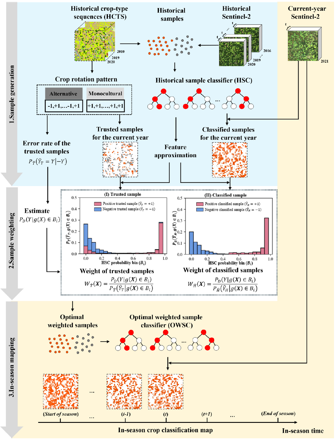
Classifier transfer and sample transfer are combined by sample weighting technique. Sample weighting is applicable to any classifiers for quick deployment.
Integrating classifier transfer and sample transfer strategies for in-season crop mapping based on sample weighting technique
Yunze Zang, Junxiong Zhou, Xuehong Chen#, ..., Jin Chen (# corresponding author)
Remote Sensing of Environment 2026
Classifier transfer and sample transfer are combined by sample weighting technique. Sample weighting is applicable to any classifiers for quick deployment.
Tracking seasonal variability in plant traits from spaceborne PRISMA and NEON AOP across forest types and ecoregions
Fujiang Ji, Ting Zheng, Alexey N. Shiklomanov, ..., Junxiong Zhou, Min Chen# (# corresponding author)
Remote Sensing of Environment 2026
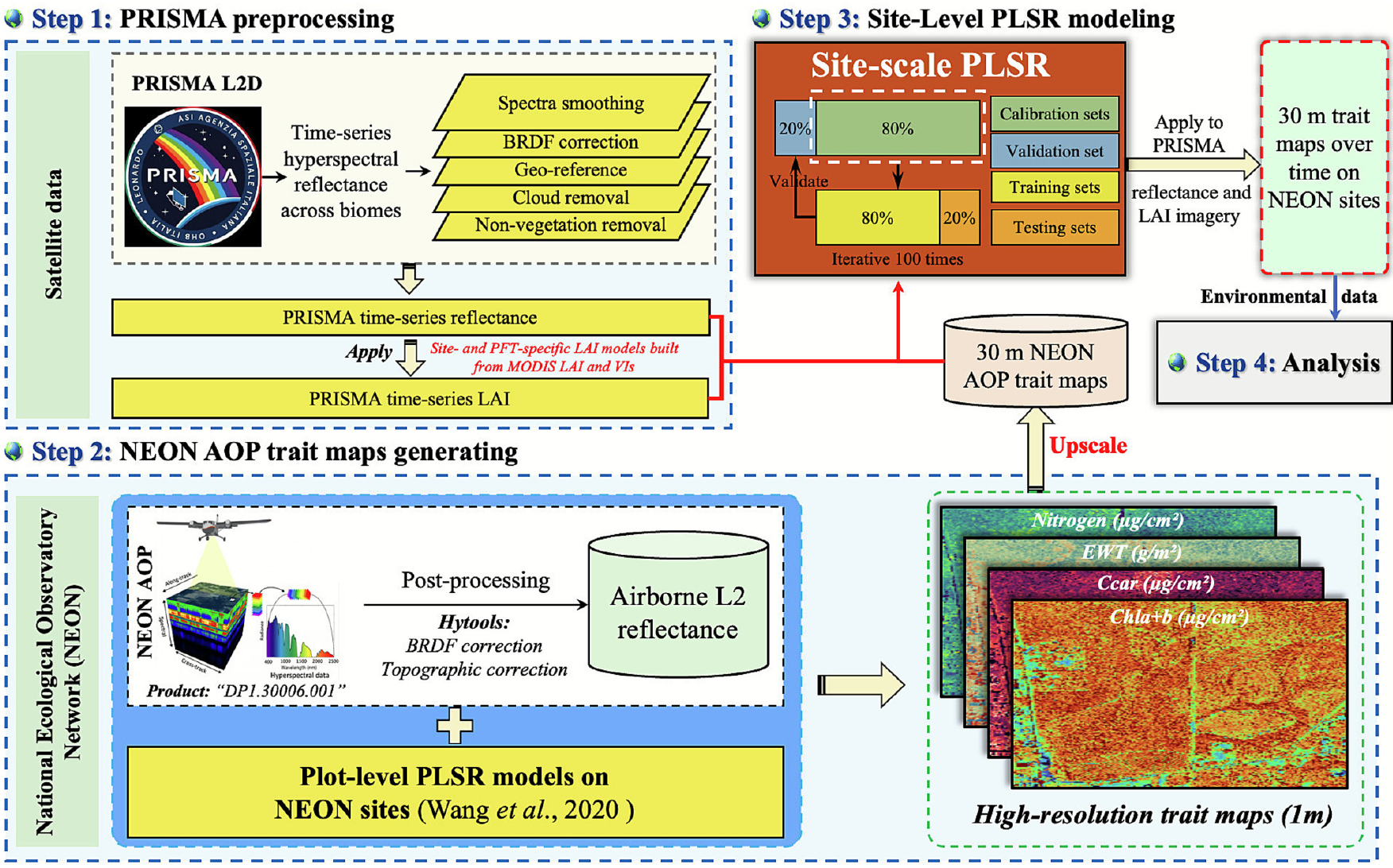
PRISMA-derived traits align well with NEON AOP traits across 11 NEON sites. Strong trait changes across forest types and ecoregions reflect seasonal functional shifts.
Tracking seasonal variability in plant traits from spaceborne PRISMA and NEON AOP across forest types and ecoregions
Fujiang Ji, Ting Zheng, Alexey N. Shiklomanov, ..., Junxiong Zhou, Min Chen# (# corresponding author)
Remote Sensing of Environment 2026
PRISMA-derived traits align well with NEON AOP traits across 11 NEON sites. Strong trait changes across forest types and ecoregions reflect seasonal functional shifts.
2025
NeRF-LAI: A hybrid method combining neural radiance field and gap-fraction theory for deriving effective leaf area index of corn and soybean using multi-angle UAV images
Qi Yang, Junxiong Zhou, Liya Zhao, Zhenong Jin# (# corresponding author)
Remote Sensing of Environment 2025
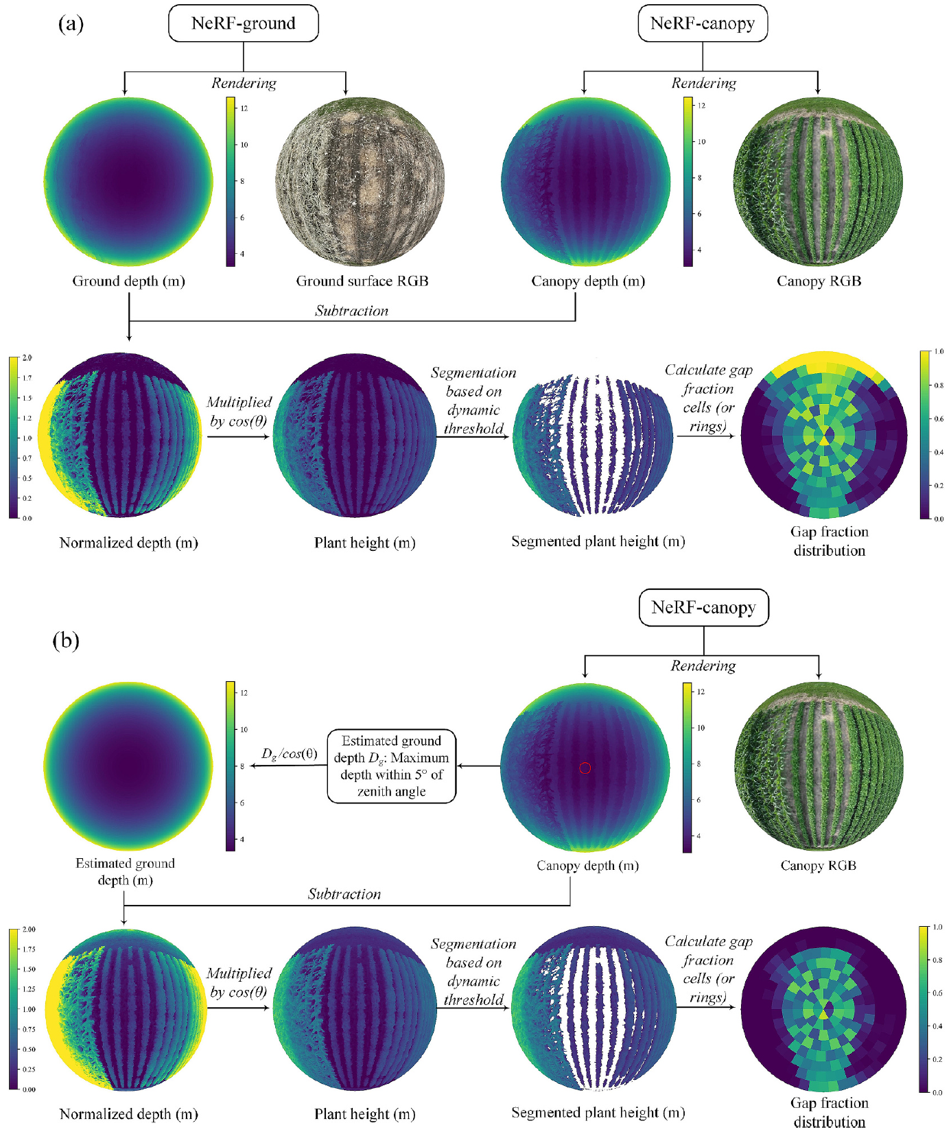
NeRF learns implicit neural representations of 3D crop fields from multi-angle images. The NeRF-LAI applies the gap fraction-based effective LAI estimation to a continuous field scale. The NeRF-LAI produces hemispherical gap fractions at an arbitrary viewpoint. The NeRF-LAI outperforms VI-based regression models in cross-site testing.
NeRF-LAI: A hybrid method combining neural radiance field and gap-fraction theory for deriving effective leaf area index of corn and soybean using multi-angle UAV images
Qi Yang, Junxiong Zhou, Liya Zhao, Zhenong Jin# (# corresponding author)
Remote Sensing of Environment 2025
NeRF learns implicit neural representations of 3D crop fields from multi-angle images. The NeRF-LAI applies the gap fraction-based effective LAI estimation to a continuous field scale. The NeRF-LAI produces hemispherical gap fractions at an arbitrary viewpoint. The NeRF-LAI outperforms VI-based regression models in cross-site testing.
Reduced Crop Yield Stability Is More Likely to Be Associated With Heat Than With Moisture Extremes in the US Midwest
Weihang Liu, Junxiong Zhou#, Yuchuan Luo, Shuo Chen, Yuchi Ma (# corresponding author)
Earth's future 2025
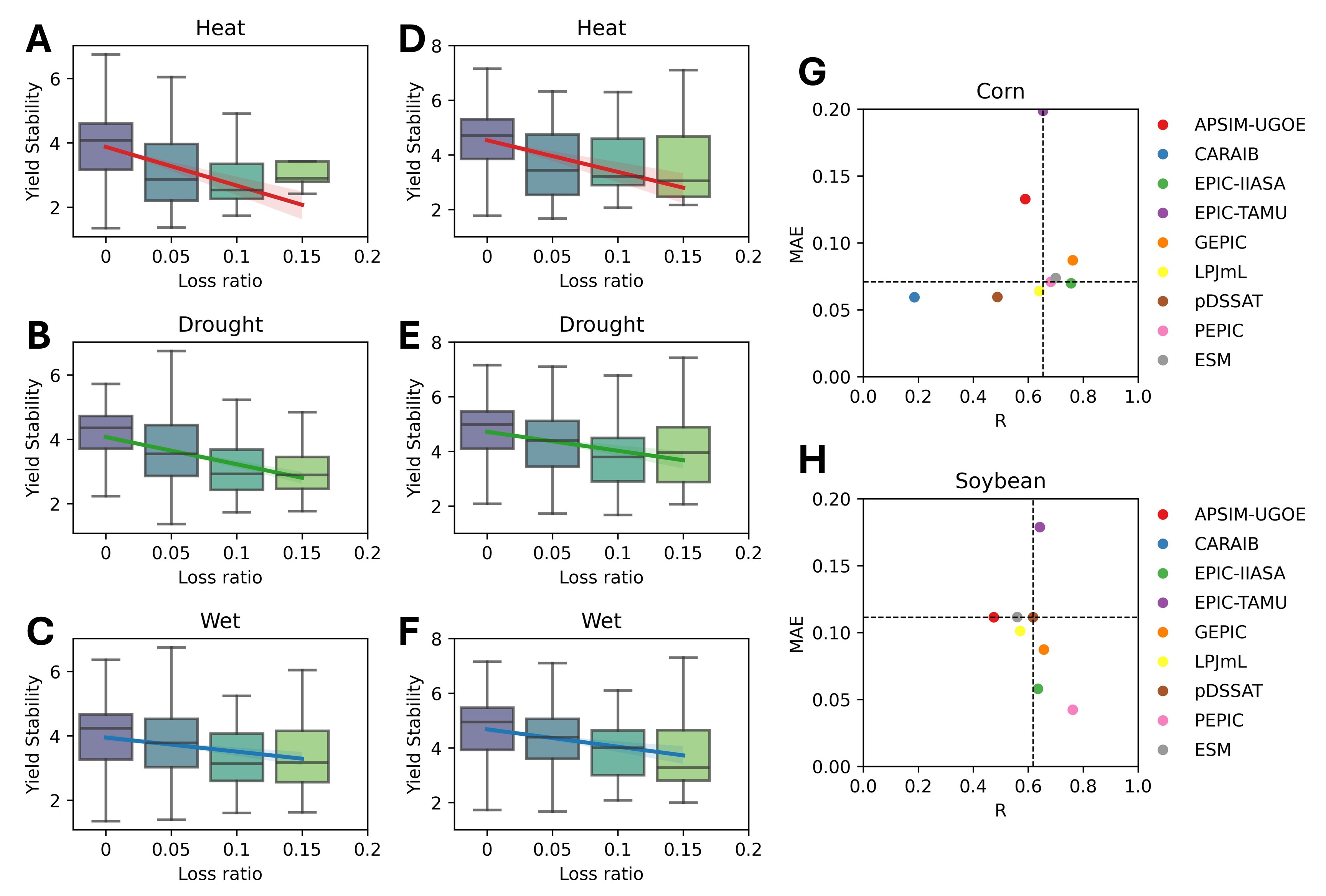
Heat is mainly linked to the changes in soybean yield stability in the US Midwest. The negative yield stability responses to heat and drought can be mitigated by the irrigation but the negative response to excess wet would be amplified. Our results highlight the importance of climate extremes on stabilizing crop yield.
Reduced Crop Yield Stability Is More Likely to Be Associated With Heat Than With Moisture Extremes in the US Midwest
Weihang Liu, Junxiong Zhou#, Yuchuan Luo, Shuo Chen, Yuchi Ma (# corresponding author)
Earth's future 2025
Heat is mainly linked to the changes in soybean yield stability in the US Midwest. The negative yield stability responses to heat and drought can be mitigated by the irrigation but the negative response to excess wet would be amplified. Our results highlight the importance of climate extremes on stabilizing crop yield.
2024
Changes in the Yield Effect of the Preceding Crop in the US Corn Belt Under a Warming Climate
Junxiong Zhou, Peng Zhu, Dan M. Kluger, David B. Lobell, Zhenong Jin# (# corresponding author)
Global Change Biology 2024 Spotlight
We examine the impacts of both GS and NGS climate conditions on the yield effect of the preceding crop in corn-soybean rotation systems from 1999 to 2018 in the US Midwest. By 2051–2070, we project that warming climates will reduce corn rotation benefits by 6.74% under Shared Socioeconomic Pathway (SSP) 1-2.6 and 17.18% under SSP 5-8.5. For soybeans, warming climates are expected to increase rotation benefits by 8.36% under SSP 1-2.6 and 13.83% under SSP 5-8.5.
Sub-national scale mapping of individual olive trees integrating Earth observation and deep learning
Chenxi Lin, Junxiong Zhou, Leikun Yin, ..., Zhenong Jin# (# corresponding author)
ISPRS Journal of Photogrammetry and Remote Sensing 2024
This study utilized cloud-free, very-high-resolution DigitalGlobe imagery collected between 2018 and 2022 to identify each individual olive tree in six northern Morocco provinces. This research represents the first-of-its-kind individual olive tree mapping at the sub-national scale that can help monitor the large-scale land conversions such as about 110,000 ha of olive plantings in the six Moroccan provinces studies here. Meanwhile it demonstrates a cost-effective and efficient prototype approach that can be adapted to identify similar tree crop expansion occurring in other parts of the world.
Shifted Flood and Ecology Regimes Due To Channel Bar Greening and Increased Flow Resistance in a Large Dammed River
Yong Hu, Jinyun Deng, Dongfeng Li#, Xixi Lu, Junxiong Zhou, Chenglong Wang, Yitian Li (# corresponding author)
Geophysical Research Letters 2024
Denser vegetation has slowed flow velocity by 17% ± 2% and increased flow resistance by 21% ± 5%, offsetting the water-level decrease from channel expansion due to scouring and even causing a slight rise in floodwater levels. Furthermore, damming has markedly altered river connectivity, thermal regimes, and solute dynamics, detrimentally affecting fish habitats and aquatic life.
Diverse responses of surface biogeophysical parameters to accelerated development and senescence of vegetation on the Mongolian Plateau
Yu Bai, Menghang Liu, Junxiong Zhou, ..., Shenggong Li# (# corresponding author)
Agricultural and Forest Meteorology 2024
The relationships between vegetation activity and environmental variables were explored. Vegetation activity was positively correlated with temperature. The trends of wind speed, solar radiation, and deep soil moisture dominate vegetation change.
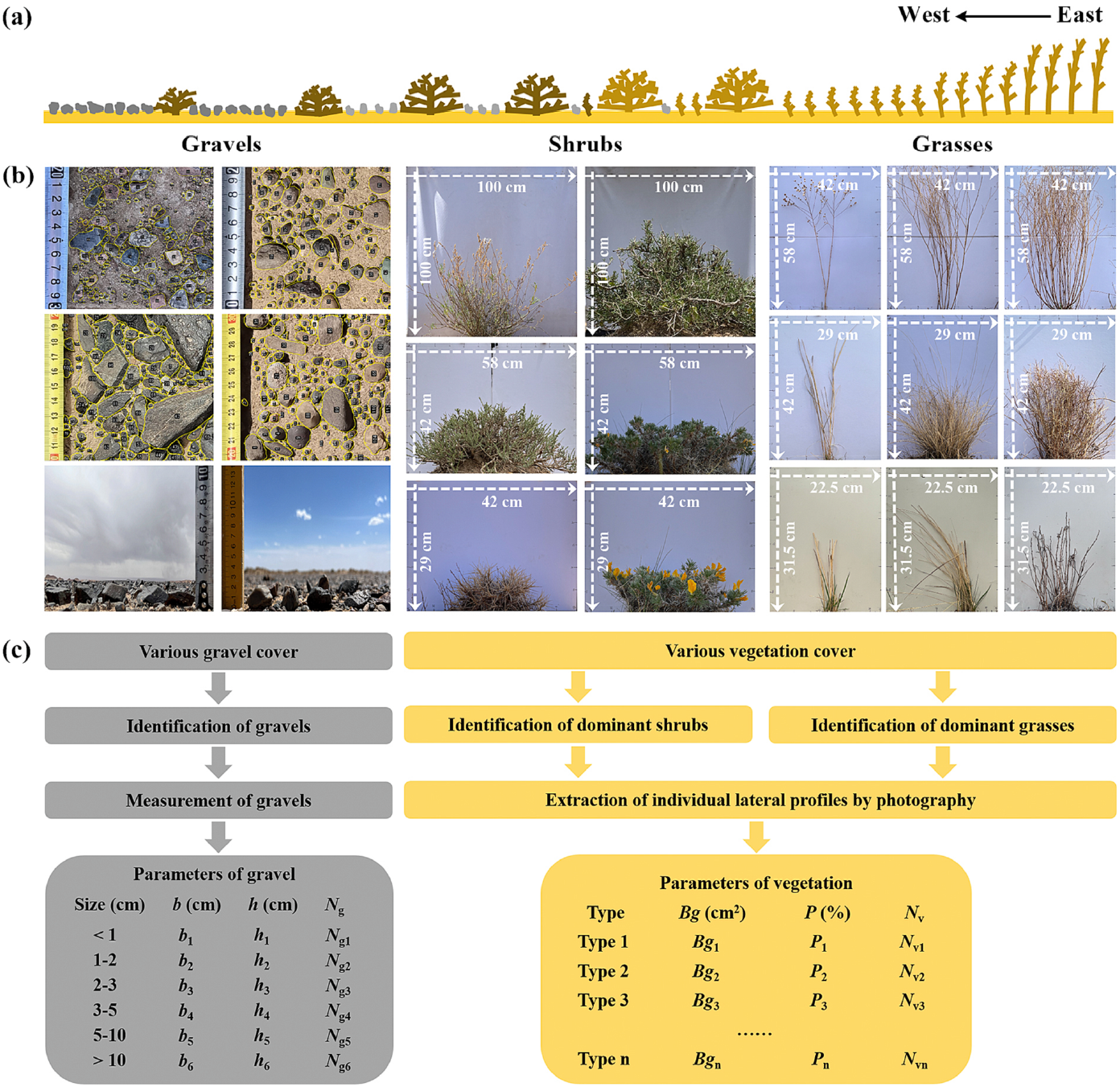
Estimating lateral cover of vegetation and gravel using NDVI and albedo
Zhuoli Zhou, Chunlai Zhang#, Xueyong Zou, ..., Junxiong Zhou, Zhihao Cao (# corresponding author)
CATENA 2024
We demonstrated the relationship between lateral cover, fractional cover and shadows. A method to estimate regional-scale vegetation and gravel lateral cover was developed. The results are of great significance for improving wind erosion and dust emission modelling.
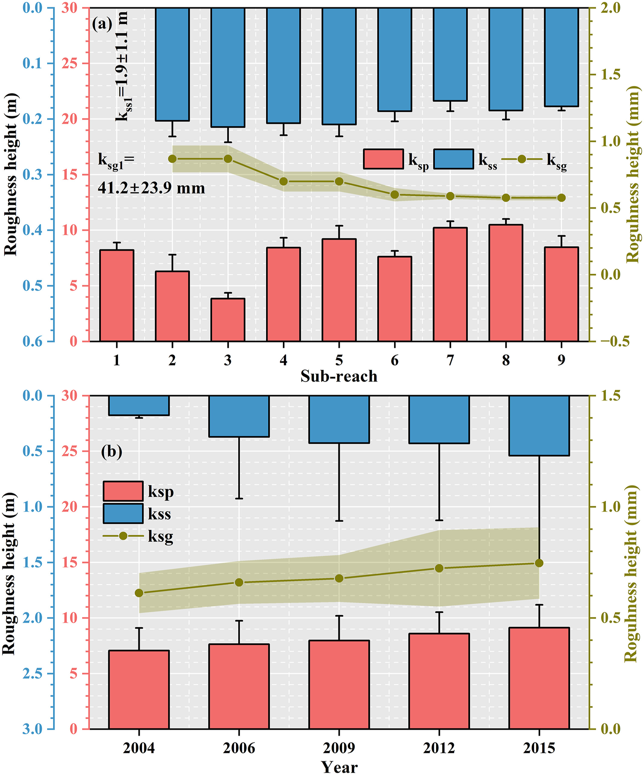
Dune Development Dominates Flow Resistance Increase in a Large Dammed River
Yong Hu, Dongfeng Li, Jinyun Deng#, Yao Yue, Junxiong Zhou, ..., Yitian Li (# corresponding author)
Water Resources Research 2024
We found that dunes developed and flow resistance increased (+10%) in the post-Three Gorges Dam period. We ascertain that the development of dunes plays the dominant role in augmenting flow resistance, as evidenced by roughness height change (+29%) using a modified Van Rijn method. Ultimately, dune development was incorporated into a hydrogeomorphic numerical model of the Yangtze River to improve flow resistance quantification, and thus, the water level simulation.
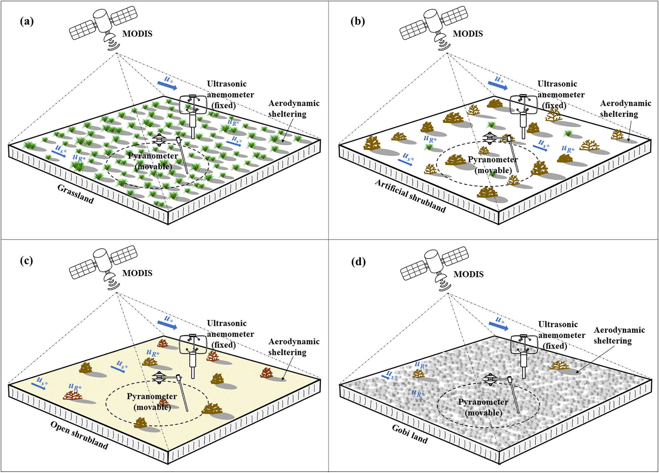
Using Field Measurements Across Land Cover Types to Evaluate Albedo-Based Wind Friction Velocity and Estimate Sediment Transport
Zhuoli Zhou, Chunlai Zhang#, Adrian Chappell, ..., Junxiong Zhou, Zhihao Cao (# corresponding author)
Journal of Geophysical Research: Atmospheres 2024
This study utilized cloud-free, very-high-resolution DigitalGlobe imagery collected between 2018 and 2022 to identify each individual olive tree in six northern Morocco provinces. This research represents the first-of-its-kind individual olive tree mapping at the sub-national scale that can help monitor the large-scale land conversions such as about 110,000 ha of olive plantings in the six Moroccan provinces studies here. Meanwhile it demonstrates a cost-effective and efficient prototype approach that can be adapted to identify similar tree crop expansion occurring in other parts of the world.
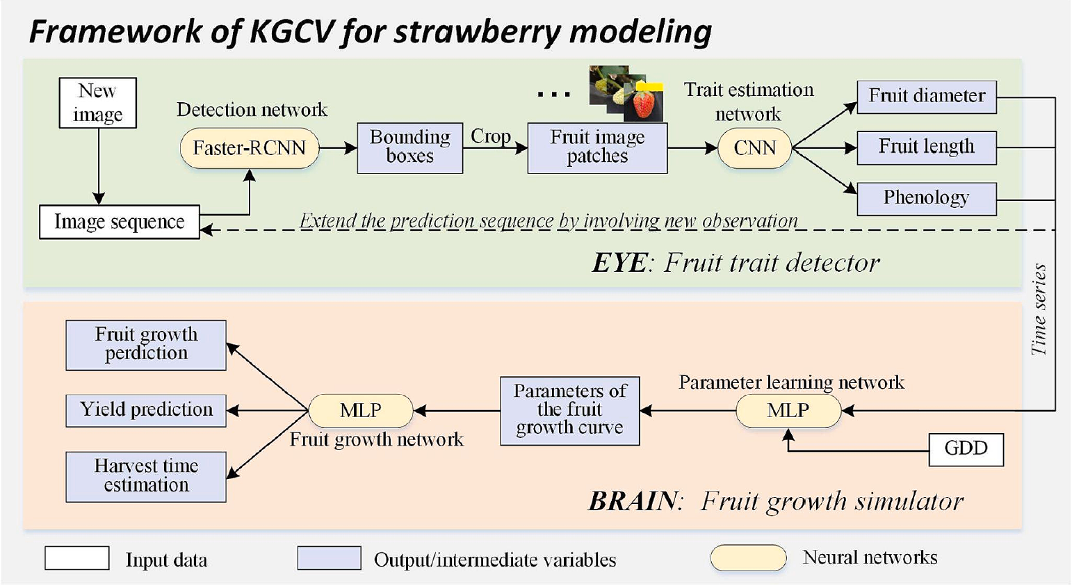
Predicting the growth trajectory and yield of greenhouse strawberries based on knowledge-guided computer vision
Qi Yang, Licheng Liu, Junxiong Zhou, ..., Zhenong Jin# (# corresponding author)
Computers and Electronics in Agriculture 2024
The KGCV-strawberry simulates fruit growth dynamics. A parameter learning network is used to infer fruit growth parameters. The KGCV-strawberry assimilates images to improve prediction.
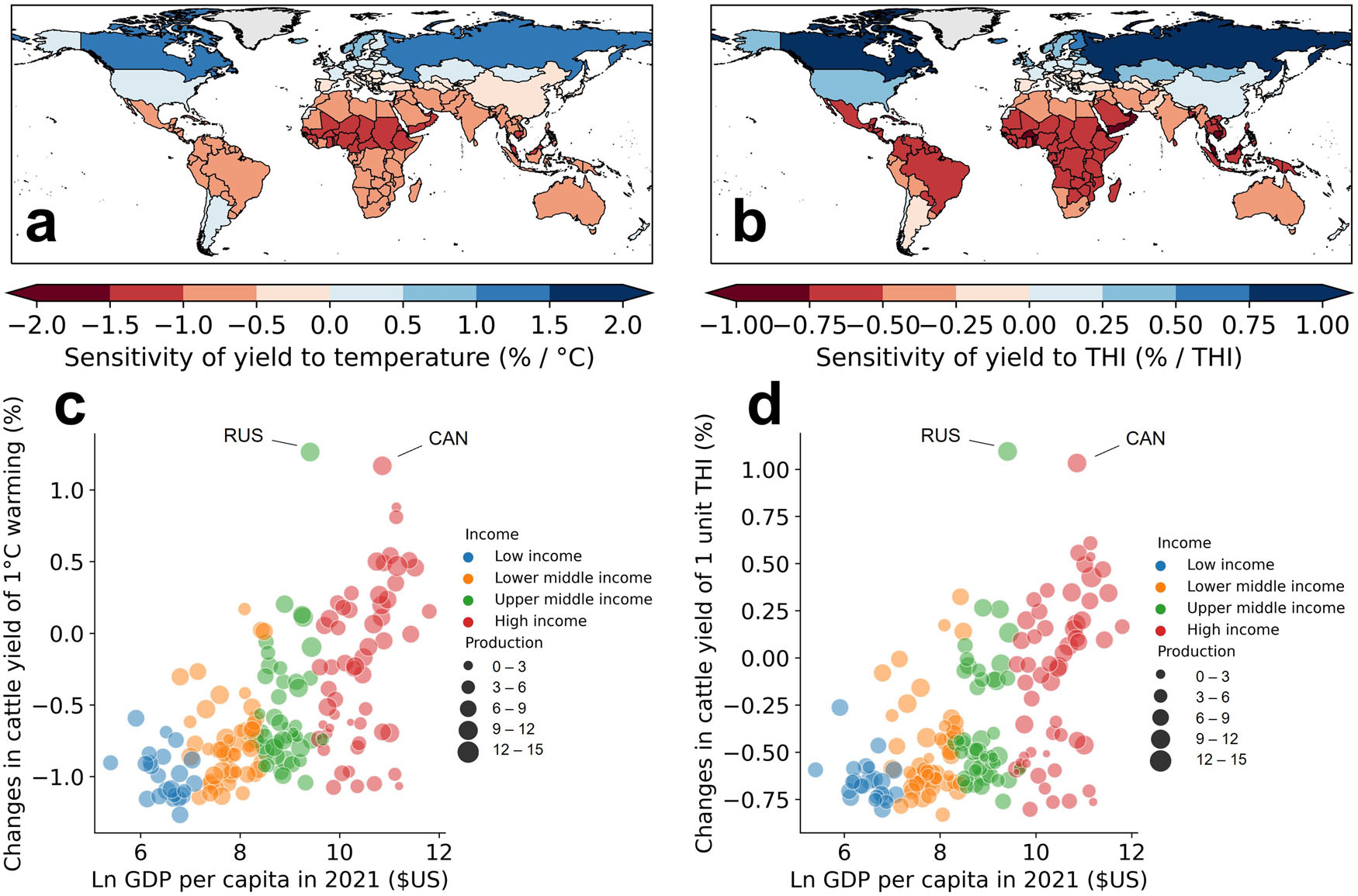
Unequal impact of climate warming on meat yields of global cattle farming
Weihang Liu#, Junxiong Zhou, Yuchi Ma, Shuo Chen, Yuchuan Luo (# corresponding author)
Communications Earth & Environment 2024
The findings show that cattle meat yield increases as temperatures rise from low to medium and then decreases when annual average temperatures exceed 7 °C; this repose is pronounced in the grassland-based livestock system. Further, we show that warming creates unequal impacts between high- and low-income countries due to the divergent baseline temperature conditions. Future warming aggravates these unequal burdens between countries, with the most pronounced effects observed under the upper-middle emissions scenario.
2023
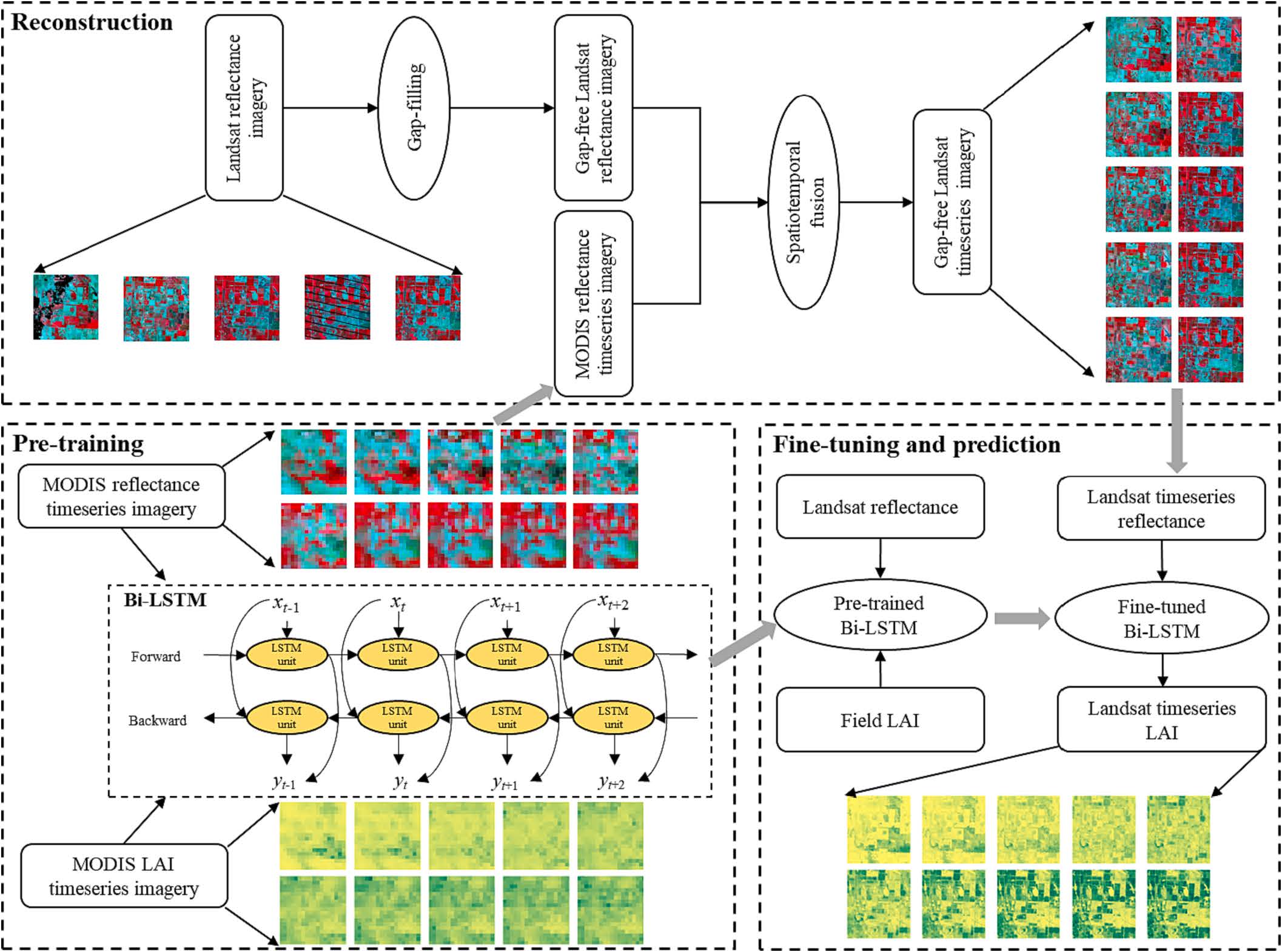
A deep transfer learning framework for mapping high spatiotemporal resolution LAI
Junxiong Zhou, Qi Yang, Licheng Liu, ..., Zhenong Jin# (# corresponding author)
ISPRS Journal of Photogrammetry and Remote Sensing 2023
This study proposed a new framework based on deep transfer learning, which includes three key features that contribute to its high performance. The findings of this study highlight the value of transfer learning in estimation of vegetation biophysical parameters, which involves pre-training using sufficient existing satellite products to produce a generalized model and transferring knowledge from in-situ measurements to bridge gaps between satellite and field.
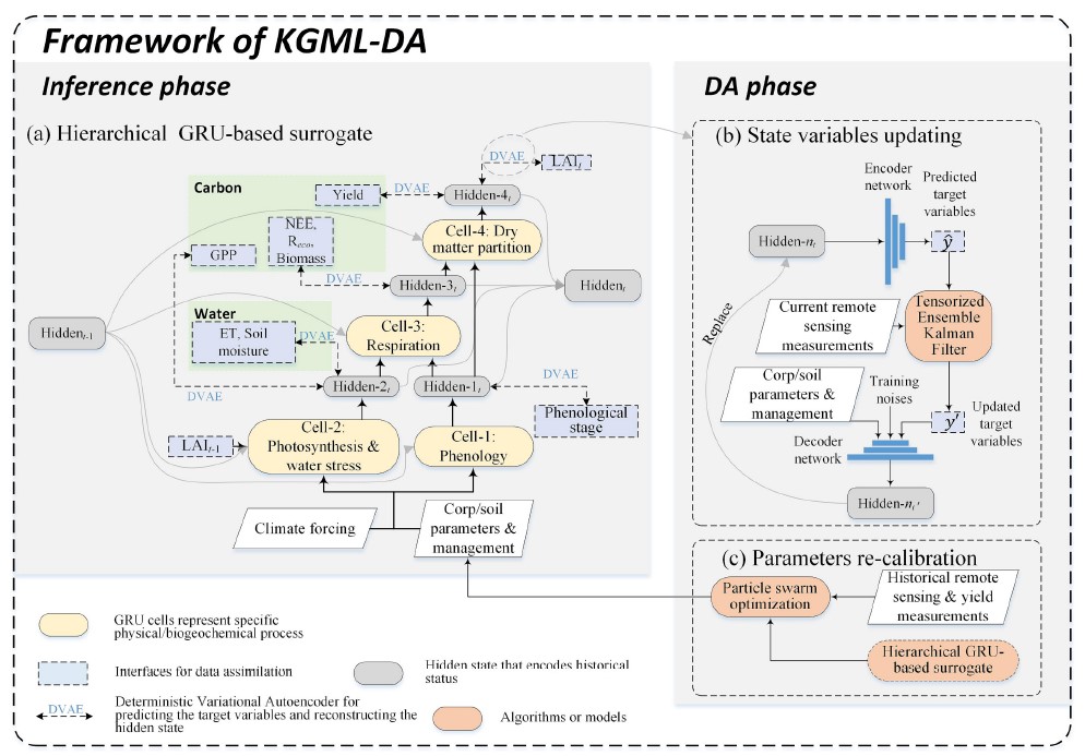
A flexible and efficient knowledge-guided machine learning data assimilation (KGML-DA) framework for agroecosystem prediction in the US Midwest
Qi Yang, Licheng Liu, Junxiong Zhou, ..., Zhenong Jin# (# corresponding author)
Remote Sensing of Environment 2023
Hierarchical GRU-based network mimics process causality of an agroecosystem model. The KGML-DA flexibly assimilates historical and in-season multi-source data. Correcting the upstream variables constrains downstream variables in KGML-DA. Joint use of historical and in-season data performs best for yield prediction.
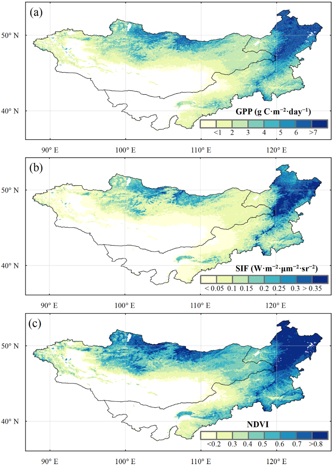
Revisiting vegetation activity of Mongolian Plateau using multiple remote sensing datasets
Yu Bai, Shenggong Li#, Junxiong Zhou, ..., Qun Guo (# corresponding author)
Agricultural and Forest Meteorology 2023
The relationships between vegetation activity and environmental variables were explored. Vegetation activity was positively correlated with temperature. The trends of wind speed, solar radiation, and deep soil moisture dominate vegetation change.
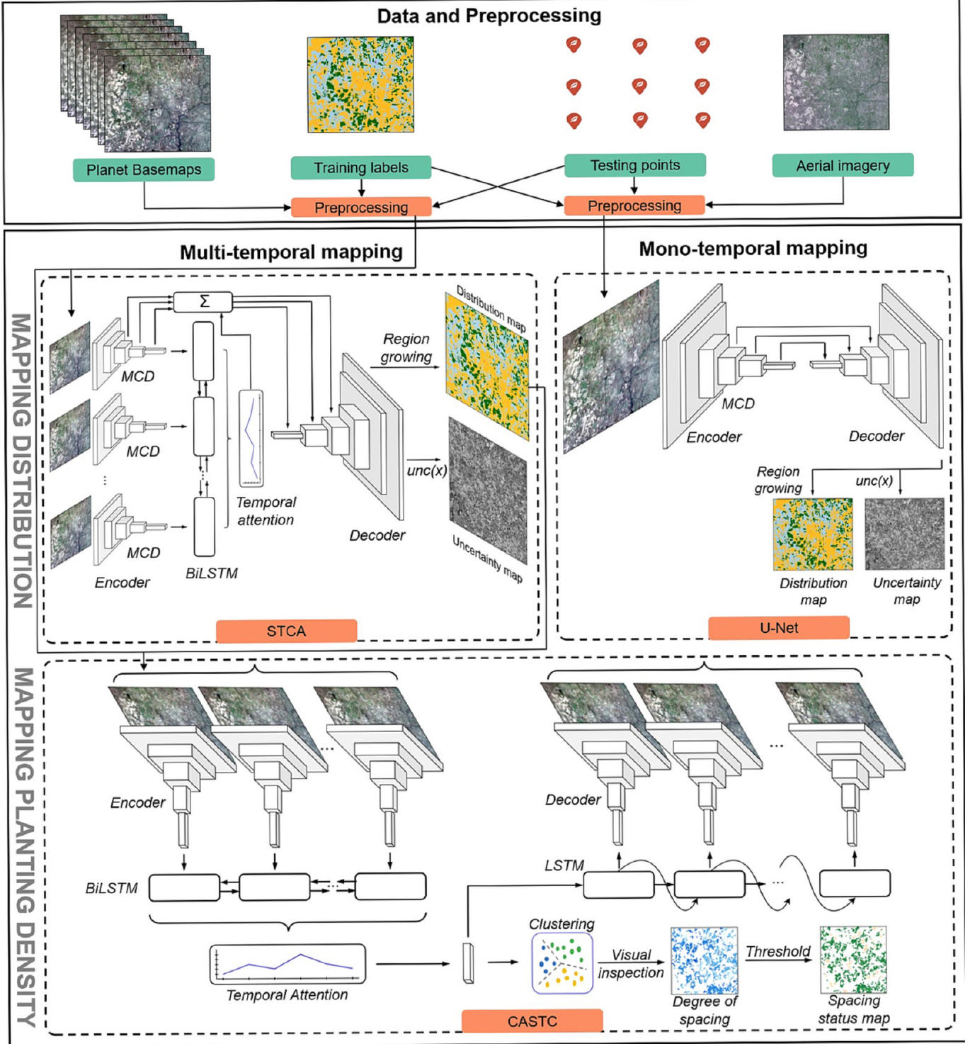
Mapping smallholder cashew plantations to inform sustainable tree crop expansion in Benin
Leikun Yin, Rahul Ghosh, Chenxi Lin, ..., Junxiong Zhou, ..., Zhenong Jin# (# corresponding author)
Remote Sensing of Environment 2023
New deep learning model for mapping cashew distribution and planting density. Cashew plantations were mapped by 2.4-m Planet Basemaps and 0.5-m aerial imagery. Cashew plantations area in Benin almost doubled from 2015 to 2021. 45 ± 6kha of cashew plantations within protected areas in 2021, a 55% rise from 2015.
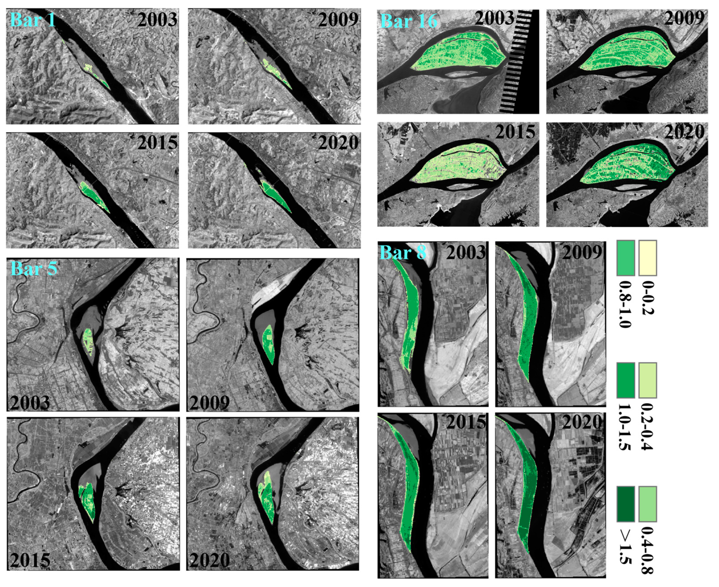
River Bars and Vegetation Dynamics in Response to Upstream Damming: A Case Study of the Middle Yangtze River
Yong Hu, Junxiong Zhou, Jinyun Deng#, ..., Dongfeng Li (# corresponding author)
Remote Sensing 2023
Our results indicate that the river bar area decreased by approximately 10% from 2003 to 2020, while the vegetation area and average LAI of these bars increased by >50% and >20%, respectively. Moreover, the plant community on most river bars tended to expand from the bar tail to the bar head and from the edge to the center. The main factor driving vegetation expansion in the MYR after the TGD’s operation was the reduction in bar submergence frequency (by 55%), along with a slight bar erosion. Further analysis revealed that the standard deviation of annual discharge decreased by approximately 37%, and the frequency of vegetation-erosive flow decreased by approximately 74%.
2022
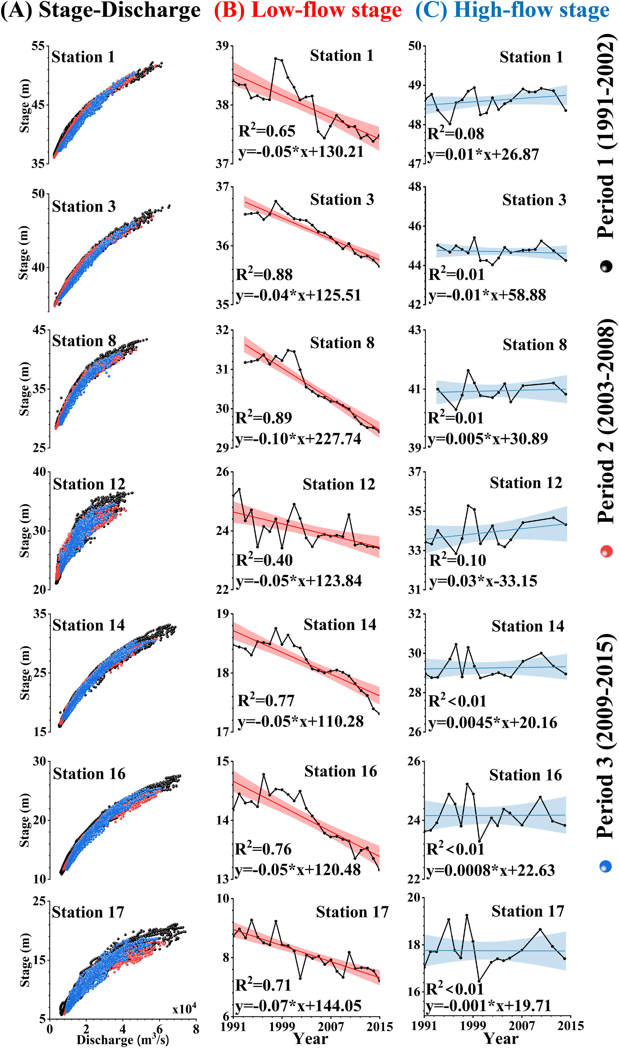
Mechanisms Controlling Water-Level Variations in the Middle Yangtze River Following the Operation of the Three Gorges Dam
Yong Hu, Dongfeng Li, Jinyun Deng#, Yao Yue, Junxiong Zhou, ..., Yitian Li (# corresponding author)
Water Resources Research 2022
An overall decline in low-flow water-levels (at a given small discharge) due to severe incisions of low-flow channels caused by a sharp reduction of ∼90% in sediment loads from 1950–2002 to 2003–2020. In contrast, high-flow water-levels (at a given large discharge) display minor changes. Our findings further the understanding of downstream geomorphic response to dam operation and their impacts on water levels and have important implications for riverine flood management in dammed river systems.
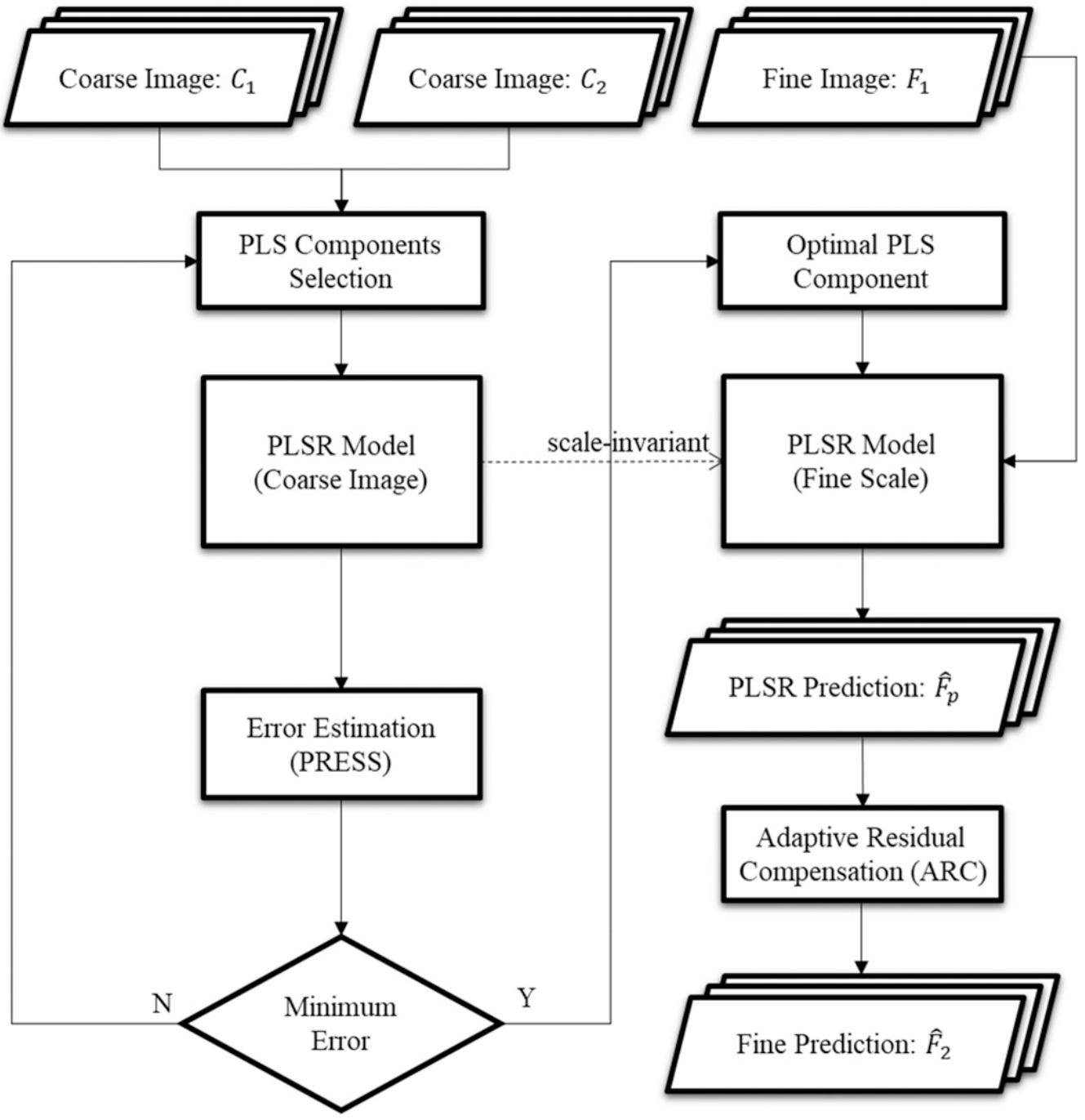
The FIRST model: Spatiotemporal fusion incorporating spectral autocorrelation
Shuaijun Liu, Junxiong Zhou, Yuean Qiu, Jin Chen#, ..., Hui Chen (# corresponding author)
Remote Sensing of Environment 2022
This study propose a novel spatiotemporal fusion method that utilizes multispectral information. Alleviate the collinearity issue by partial least squares regression (PLSR). Stable and accurate performances even with cloud-contaminated input images.
A novel framework to assess all-round performances of spatiotemporal fusion models
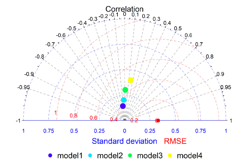
Xiaolin Zhu, Wenfeng Zhan, Junxiong Zhou, ..., Jin Chen# (# corresponding author)
Remote Sensing of Environment 2022
A framework was proposed to assess all-round performances of fused images. RMSE, AD, Edge, LBP were selected as optimal metrics. A polar diagram was designed to visualize accuracy measurements with bottom lines. It can guide users to select appropriate fusion methods for different applications.
A novel framework to assess all-round performances of spatiotemporal fusion models
Xiaolin Zhu, Wenfeng Zhan, Junxiong Zhou, ..., Jin Chen# (# corresponding author)
Remote Sensing of Environment 2022
A framework was proposed to assess all-round performances of fused images. RMSE, AD, Edge, LBP were selected as optimal metrics. A polar diagram was designed to visualize accuracy measurements with bottom lines. It can guide users to select appropriate fusion methods for different applications.
Detection of Soil Freeze/Thaw States at a High Spatial Resolution in Qinghai-Tibet Engineering Corridor
Xihong Cui, Zhenxian Quan, Xuehong Chen, Zheng Zhang, Junxiong Zhou, ..., Li Guo# (# corresponding author)
IEEE Geoscience and Remote Sensing Letters 2022
A new approach integrating two microwave sensors is developed to identify the soil F/T state at a spatial resolution of 10 m in the Qinghai-Tibet engineering corridor. The overall accuracy of the 10-m soil F/T map achieves 84.63% and 77.09% for ascending and descending orbits based on four meteorological stations, respectively.
2021
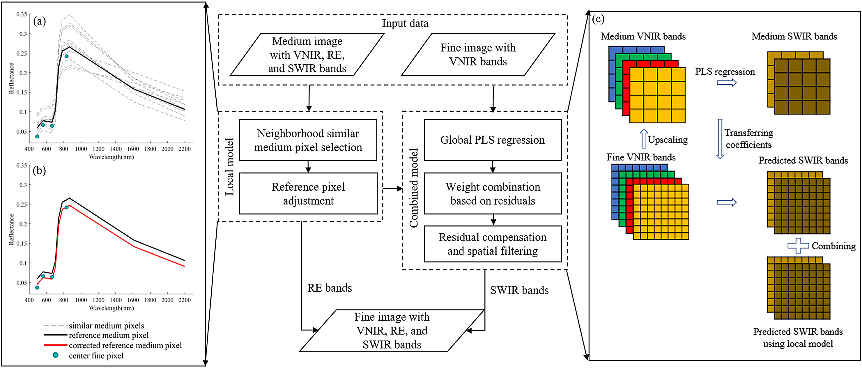
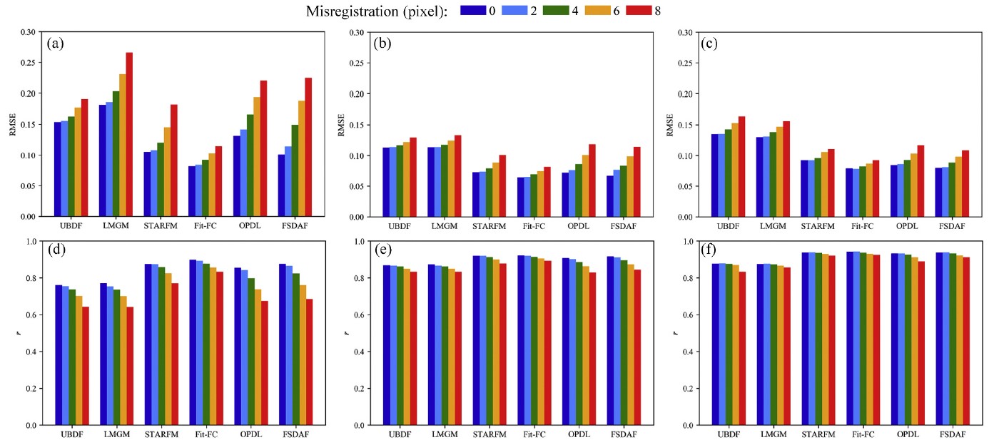
A geometric misregistration resistant data fusion approach for adding red-edge (RE) and short-wave infrared (SWIR) bands to high spatial resolution imagery
Junxiong Zhou*, Yuean Qiu*, Jin Chen#, Xuehong Chen (* equal contribution, # corresponding author)
Science of Remote Sensing 2021
MRDF is robust to geometric registration errors between multi-satellite sensors. MRDF can achieve stable and accurate fusion and classification performances.
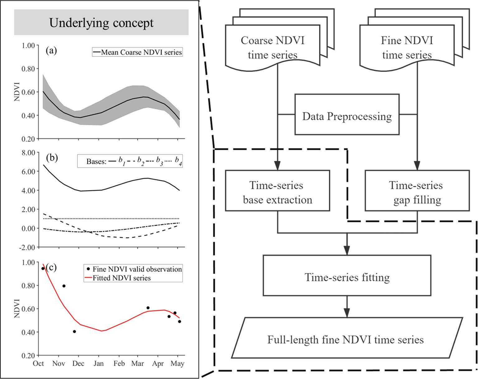
Spatiotemporal fusion method to simultaneously generate full-length normalized difference vegetation index time series (SSFIT)
Yuean Qiu, Junxiong Zhou, Jin Chen#, Xuehong Chen (# corresponding author)
International Journal of Applied Earth Observation and Geoinformation 2021
This study proposes a novel spatiotemporal fusion method for NDVI time series. This method is stable and accurate performances under challenging input conditions.
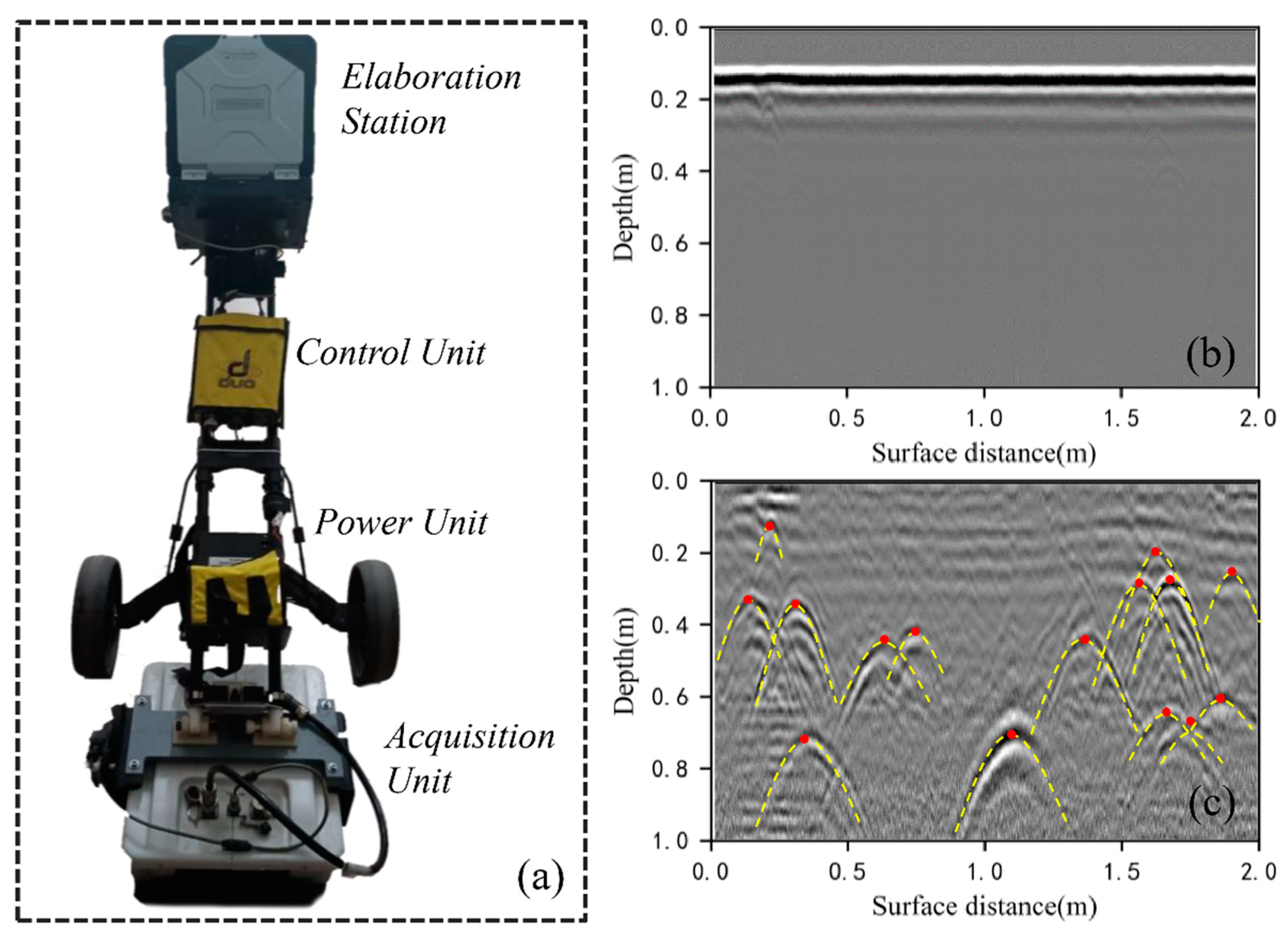
GPR-Based Automatic Identification of Root Zones of Influence Using HDBSCAN
Xihong Cui, Zhenxian Quan, Xuehong Chen, Zheng Zhang, Junxiong Zhou, ..., Li Guo# (# corresponding author)
Remote Sensing 2021
This study has developed a new approach to determining the ZOIs within natural plant communities.The ZOIs extracted based on GPR survey data were highly consistent with the actual growth pattern of shrub roots and can thus be used to reveal the spatial competition strategies of plant roots responding to changes in the soil environment and the influence of neighboring plants.
Sensitivity of six typical spatiotemporal fusion methods to different influential factors: A comparative study for a normalized difference vegetation index time series reconstruction
Junxiong Zhou, Jin Chen, Xuehong Chen#, Xiaolin Zhu, ..., Xihong Cui (# corresponding author)
Remote Sensing of Environment 2021
This study compared six typical spatiotemporal fusion methods. Sensitivity to radiometric/geometric errors was explained by theoretical analysis. The findings could help users determine the method that is appropriate for different remote sensing datasets, and provide guidelines for developers in the future development of novel methods.