.")
I have experience in remote sensing image processing, including image fusion and classification. My current research interest includes climate change adaptation based on sustainable agriculture solutions and Earth observations.
Warning
Problem: The current name of your GitHub Pages repository ("Solution: Please consider renaming the repository to "
http://".
However, if the current repository name is intended, you can ignore this message by removing "{% include widgets/debug_repo_name.html %}" in index.html.
Action required
Problem: The current root path of this site is "baseurl ("_config.yml.
Solution: Please set the
baseurl in _config.yml to "Education
-
 University of Minnesota Twin CitiesDepartment of Bioproducts and Biosystems Engineering
Dr. Zhenong Jin and Dr. Ce Yang
Ph.D.Sep. 2021 - Oct. 2025 -
 Beijing Normal UniversityFaculty of Geographical Science
Dr. Jin Chen
M.S.Sep. 2018 - Jun. 2021 -
 China University of GeosciencesFaculty of Information Engineering
B.E.Sep. 2014 - Jun. 2018
Experience
-
 University of California, BerkeleyEric and Wendy Schmidt Center for Data Science & Environment
Dr. Douglas McCauley and Dr. Justin S. Brashares
PostdocNov. 2025 - present -
 University of Wisconsin-MadisonBiological Systems Engineering
Dr. Licheng Liu
Research AssociateFeb. 2026 - present
News
Selected Publications (view all )
NeRF-LAI: A hybrid method combining neural radiance field and gap-fraction theory for deriving effective leaf area index of corn and soybean using multi-angle UAV images
Qi Yang, Junxiong Zhou, Liya Zhao, Zhenong Jin# (# corresponding author)
Remote Sensing of Environment 2025
NeRF learns implicit neural representations of 3D crop fields from multi-angle images. The NeRF-LAI applies the gap fraction-based effective LAI estimation to a continuous field scale. The NeRF-LAI produces hemispherical gap fractions at an arbitrary viewpoint. The NeRF-LAI outperforms VI-based regression models in cross-site testing.
Reduced Crop Yield Stability Is More Likely to Be Associated With Heat Than With Moisture Extremes in the US Midwest
Weihang Liu, Junxiong Zhou#, Yuchuan Luo, Shuo Chen, Yuchi Ma (# corresponding author)
Earth's future 2025
Heat is mainly linked to the changes in soybean yield stability in the US Midwest. The negative yield stability responses to heat and drought can be mitigated by the irrigation but the negative response to excess wet would be amplified. Our results highlight the importance of climate extremes on stabilizing crop yield.
Changes in the Yield Effect of the Preceding Crop in the US Corn Belt Under a Warming Climate
Junxiong Zhou, Peng Zhu, Dan M. Kluger, David B. Lobell, Zhenong Jin# (# corresponding author)
Global Change Biology 2024 Spotlight
We examine the impacts of both GS and NGS climate conditions on the yield effect of the preceding crop in corn-soybean rotation systems from 1999 to 2018 in the US Midwest. By 2051–2070, we project that warming climates will reduce corn rotation benefits by 6.74% under Shared Socioeconomic Pathway (SSP) 1-2.6 and 17.18% under SSP 5-8.5. For soybeans, warming climates are expected to increase rotation benefits by 8.36% under SSP 1-2.6 and 13.83% under SSP 5-8.5.
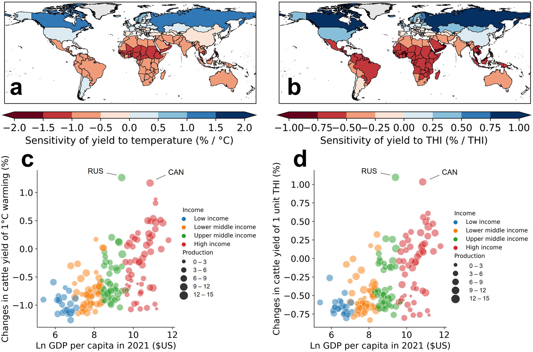
Unequal impact of climate warming on meat yields of global cattle farming
Weihang Liu#, Junxiong Zhou, Yuchi Ma, Shuo Chen, Yuchuan Luo (# corresponding author)
Communications Earth & Environment 2024
The findings show that cattle meat yield increases as temperatures rise from low to medium and then decreases when annual average temperatures exceed 7 °C; this repose is pronounced in the grassland-based livestock system. Further, we show that warming creates unequal impacts between high- and low-income countries due to the divergent baseline temperature conditions. Future warming aggravates these unequal burdens between countries, with the most pronounced effects observed under the upper-middle emissions scenario.